9. World Map
Feb 14, 2014 19:43:52 GMT -7
Post by Wolfy on Feb 14, 2014 19:43:52 GMT -7

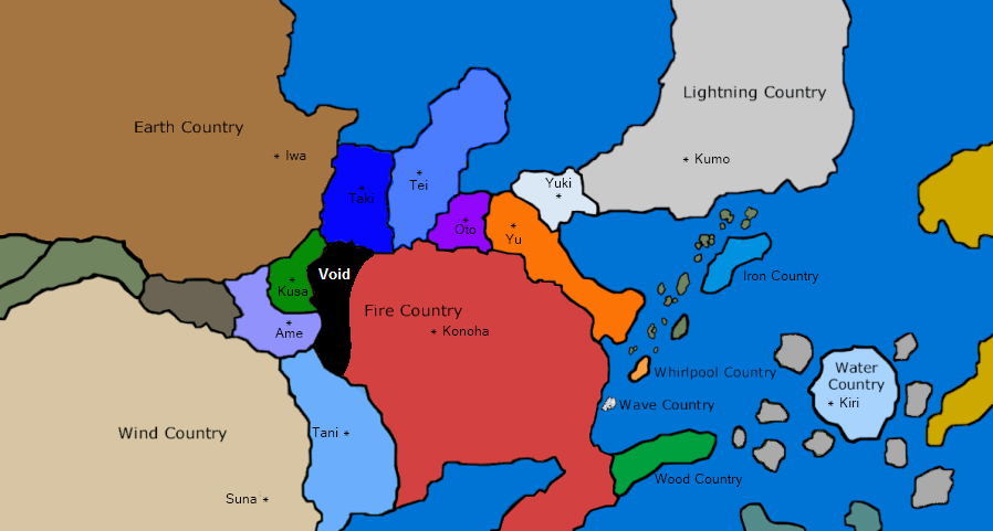
[/ul]Above you will find a map that gives the general overview of NRR's geography, specifically points of interest within each country. As you can see, it is slightly different from that of the canon; because of various wars and the erosion of time, access to many areas has become impossible. Moreover, knowledge of these long-forsaken places has been lost more and more with each successive generation. Many of these landmarks are the crossover points of leylines running under the land causing wellsprings of powerful chakra to build up, these places drew shinobi together and together they built their villages, and with time came the development of Unique Abilities that can only grow and bloom within the village.
You are free to refer to this map when traveling, setting up missions, etc. Be forewarned that the geography may change marginally as plot progresses on our site! It is entirely possible for one country to take over another, thereby gaining more land to call its own. If that should happen, the map will be updated to better inform the players; pieces of land with the same color signify that this land is being ruled by the same power.— Tenzaku Gai.
2 — Forest of Death.
4 — Valley of the End.
 — Sunagakure, within Kaze no Kuni.
[/ul]
 — Kirigakure, within Mizu no Kuni.
[/ul]
 — Kumogakure, within Kaminari no Kuni.
2 — Island Turtle.
[/ul]
 — Iwagakure, within Tsuchi no Kuni.
[/ul]
 — Kusagakure, within Kusa no Kuni.
[/ul]
 — Yukigakure, within Yuki no Kuni.
[/ul]
[/ul][/font][/div][/blockquote]


